Back in mid-August, a buddy and I took off on an adventure. The original plan was to visit a site someone had told us about up near Wiseman, Alaska. The scenery was supposed to be stunning, the gold and semi-precious stones easy to find, and –best of all– the mining claim was lapsed so we wouldn’t technically be doing anything illegal.
I’m a skeptical person and this all sounded a bit too good to be true, but I went along with it anyway. Even if it didn’t pan out– pun intended– it’d still be a great adventure, right?
A little bit of history: Wiseman is roughly 300 miles north of Fairbanks on the Dalton Highway, the so-called Haul Road that connects Alaska’s farthest north transportation hub with the North Slope. As of the 2010 census, it had a population of 14 people. The nearest community is Coldfoot, population 10.
The history of these two communities has been entwined since gold was first discovered in the area in 1899. While the initial goldrush didn’t last long, mining has continued off and on in the area since. Which brings us to today, and the now-abandoned industrial-scale Nolan Mine.
The Rise And Fall Of A Dream
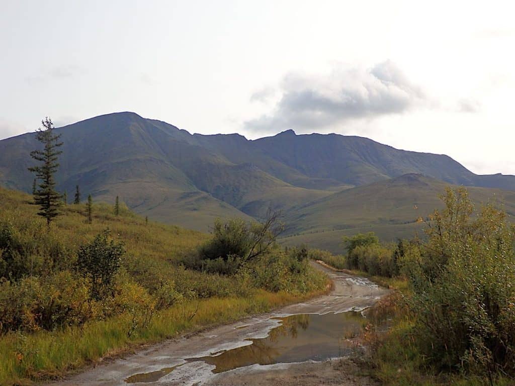
After driving up the Haul Road for most of the morning and afternoon, it was 5 pm by time we reached the turnoff for Wiseman. The Nolan Road forks off about a half mile in, and to call it a proper road would be, at best, a bit of a stretch. It’s six miles of muddy, largely-unimproved nastiness.
To be fair, parts of it aren’t bad. In other places, little creeks and springs have washed peat mud and glacial silt off the flanks of Midnight Dome and deposited it on the roadbed, creating mud pits that range from a few inches to a few feet deep. In the interest of not getting stuck hundreds of miles from a tow, I approached these with caution.
Hoping that the payoff was worth it and crossing our fingers that there weren’t even deeper mud holes ahead, we decided to keep going. Eventually, about five miles in, we were confronted by a heavy duty steel gate secured with a chain with links thicker than my finger and four of the biggest padlocks I’ve ever seen.
“There’ll be a gate. Don’t worry, just cut the lock. You’re just passing through and they can’t block the road,” our source had told us. I was skeptical to begin with, but this was nothing like what I’d expected. Someone really didn’t want people passing this gate.
“Maybe you should have brought your welding torch,” I joked. My heavy duty bolt cutters looked woefully inadequate next to the chain and locks.
After a brief debate, we decided to walk up the road and see what was over the rise and around the corner. Was there an active mine up here after all? We’d been told the place was abandoned, but the road had seen quite a bit of recent traffic.
It turned out to be a good thing we did. Around a half mile farther in, we found a six-foot-deep, twelve-foot-wide washout where the road crossed Nolan Creek. Gate or no gate, we weren’t going to be able to continue to our destination.
We also found indications that someone had picked up one or more of the vacant mining claims in the area, and a set of massive wolf prints. On the way back to my truck, we were treated to this amazing view over the Nolan Creek valley to an unnamed ridge in the south.
Defeated, disappointed, and dreading the trip back through the mud pits, we headed back to the highway.
Retreat and Reconsider
By time we got back to the highway it was closing in on 8 pm, one of my tires was slowly going flat, and we were no closer to being able to set up camp for the night– or even knowing where we were going to camp. We decided to head back down the highway toward Coldfoot, where we’d passed a public campground.
This turned out to be a fortuitous choice. The Marion Creek Campground is definitely one of the nicest campgrounds I’ve visited in my home state. The free firewood was a welcome surprise, and saved us from having to slog through the woods in search of firewood so we could warm up and cook dinner.
(Note for those reading this in light of the drought and catastrophic wildfires in other parts of the US: Alaska’s monsoon season started at the beginning of August. The Wiseman and Coldfoot area was in absolutely no danger of catching fire by time we got there.)
While exploring the campground, we stumbled across a handmade sign that said simply, “Falls.” The words were written in charcoal on a piece of scrap wood. An arrow pointed to a well-trodden trail and the distant sound of rushing water. After a brief exploration in the failing light, we decided the falls were an adventure for morning.
Marion Creek
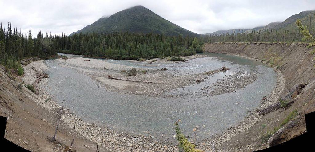
The following day we set off in search of the elusive Marion Creek falls. The first indication that the creek might be something more like a river, at least in the spring, was this curve in the stream and the truly massive cut bank it had created.
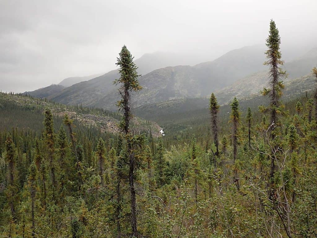
Beyond this spectacular view, the path deteriorated into little more than a muddy game trail. It climbed the flank of the hill south of the river, then traveled east, paralleling the valley below. We continued to hear roaring water, and eventually spotted the falls in a crease between the foot of the hill we were on and a rocky outcrop at the bottom of the hill across the way. (This outcrop would prove to be significant later.)
About two miles from the trailhead, the path plunged downhill and we arrived on the bank above the falls.
Here, the river is bounded by jagged bedrock on the south side and the heavily eroded toe of the hill on the north. Car-sized chunks of rock break the stream, exposed by the force of the water.
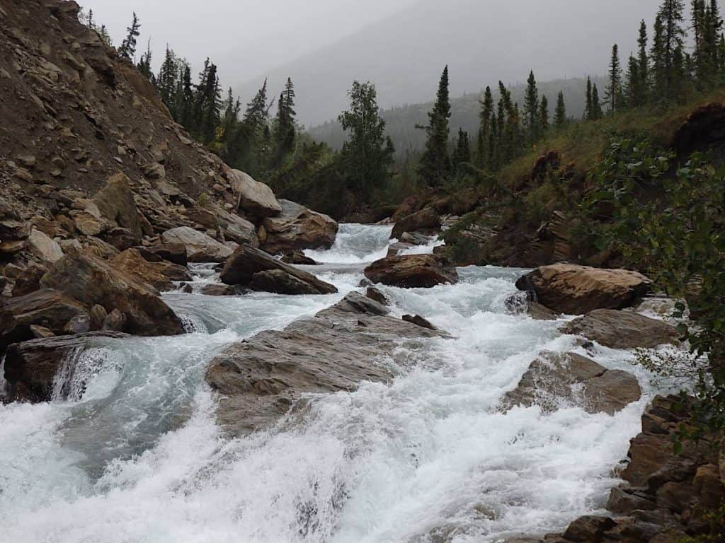
The falls themselves could probably be best described as a series of treacherous white-water rapids, whirlpools, and short drops like the ones below. Although they’re not what some people might think of when they read “falls,” they’re no less thrilling. The roar of the water is deafening, and even in late summer the rate of flow is impressive– and impressively dangerous.
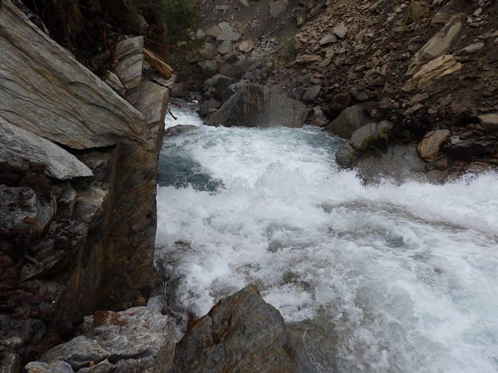
This valley, like most in the area, is surrounded by steep four and five thousand foot peaks. This narrow notch clearly sees an incredible amount of water in the spring as the snow on the surrounding mountains melts.
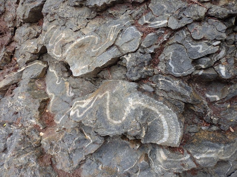
We hopped down onto a shelf of bedrock next to the water, and discovered this crazy pattern of folds in the rock face. The twisting and melting that created this formation must have been spectacular!
The rest of the trip involved lots of rain and wind, and temperatures that hovered in the low 40s Fahrenheit. On our final morning, the clouds parted long enough to reveal snow on the higher peaks. It was an adventure, and like most adventures, it felt great to return home.
An Unexpected Surprise
Looking at satellite imagery of the Marion Creek valley after returning home, I made one last exciting discovery: this massive old landslide.
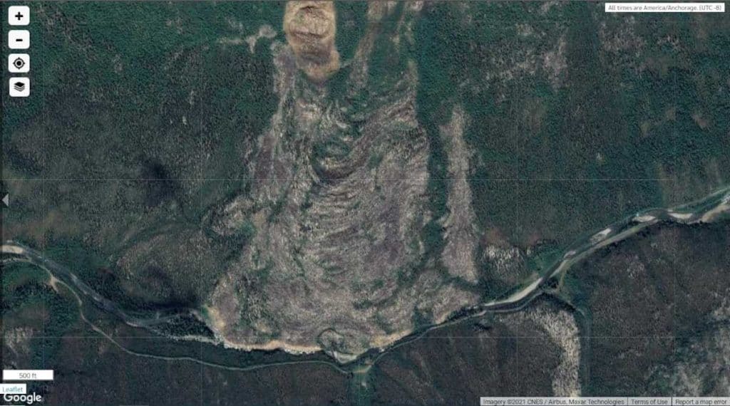
Go back and have a second look at the shot of the distant falls in their “notch” in the valley, and the close-up of the rapids below the bank of loose dirt and rock. That’s not an outcrop; that’s the toe of a landslide. That’s not just an erosion-spawned cut bank; that soil is so loose because not long ago (geologically speaking) it was sliding down the side of a mountain. Ditto for the car-sized boulders in the creek.
As someone with an interest in terrain, geology, and geography, this was a really cool discovery. It’s hard to say how long ago this massive landslide occurred. It was overgrown enough that, from the ground, I had no idea it was there. I dug up historical satellite imagery of the area, which unfortunately only goes back to 1984, and the slide was clearly visible but showed signs of advanced plant cover even back then.
I’ve searched fruitlessly for some documentation of when this slide happened, and as far as I can tell no record of it exists online. If you’ve stumbled across this post because you’re researching this slide or something related, please get in touch– I’d like to know what you’ve learned.
That’s it for now, but I’m definitely planning to make it back to this part of Alaska in the future. There’s clearly more exploring to be done!
Article and photography © 2021 Leland Lydecker.
Satellite image © 2021 CNES / Airbus, Maxar Technologies.

mjo says:
Off this topic, but I just wanted to say how very glad I was, to see Di’s return to operations at Baron Cargo, if in a different ‘form’.
Leland Lydecker says:
Thank you! I’m glad you like that. 🙂
Jay says:
NOLAN creek is completely and legally staked and claimed up, your “source”
is full of it. I have over a dozen claims there. The gate was there to keep you out and safe, cutting the chain or lock is a federal offense. The “road” is not passable anymore and there’s no
Cell phone service, no tow trucks and we had to get the CAT out and drag the last abandoned and burned truck out of the way. Claim jumping is a serious offense.
Leland Lydecker says:
Chill out buddy, you’re about two years too late. We came out to have a look around and check on a tip, and we did that. We also researched the applicable laws before we went, and came prepared for both bears and crazy miners. The Nolan Road isn’t that scary by Alaskan standards, just sketchy; I’ve been down far worse as a commercial driver. Most of Alaska has no cell service and is hundreds of miles from the nearest tow. Stop trying to scare people and don’t say stuff that reflects poorly on you.
john baden says:
i have 9 million shares of silverado gold mines which includes the nolan..i wastold that silverado went out of business ..i would like to know if i have shares in the mine or did i lose evert thing thank you
PedroTheLion says:
This was a great account of what sounds like a fun memory with your buddy, an adventure you’ll never forget! Thanks for the detail and sharing- made me think that Marion creek campground will be our spot!
Derick Williams says:
Really interesting article. I came across this blog for my research into visiting Gates of the Arctic NP. I would like to explore the borderland of the park as it approaches the Dalton Highway and the towns of Wiseman and Coldfoot. Would love to hear more about your experience in that part of Alaska. I have included my email if you wanted to chat more and had the time to share some thoughts with another traveler. Thanks! – Derick
M.N. says:
Thanks for the post. Marion CG is on my 2026 agenda as is hiking the Nolan Rd. Precious little information out there. Thanks again.